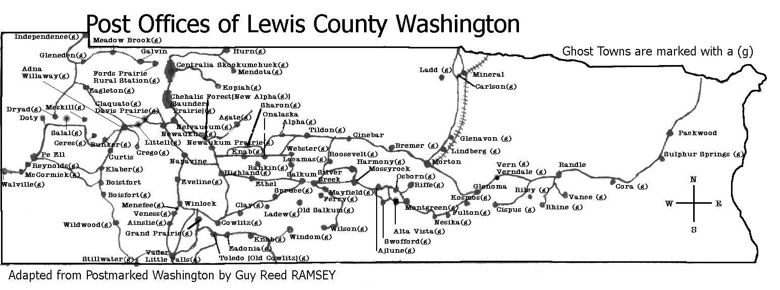
Sources listed in parentheses are found in the Bibliography. If you would like to make any additions or corrections to the information posted, please e-mail me.
Macomber
Station on the Cowlitz, Chehalis and Cascade Railway, 12 miles from Chehalis. "The name of Doty's Spur station has been changed to 'Macomber' in honor of the well known family of that name who own land and live adjoining." (Chehalis Bee-Nugget, 9 Feb 1923, p. 7).
Mary's Corner
Located 10 miles southwest of Chehalis on US Hwy 12. It was named for Mary Rogers who ran a store there in the 1920s.
Mary's Corner Links:
- Jackson (Koontz) Cemetery - transcribed for the Washington Tombstone Transcription Project
Mauermann
This precinct is listed in the 1910 census. The Mauermanns were one of the first families to settle in the area now known as Pe Ell, so Mauermann is probably adjacent to Pe Ell. Currently, the Mauermann Voting District takes up the southwestern corner of Lewis County, surrounding PeEll (which is a separate voting district).
Mauermann Links:
- 1910 Census Index, Mauermann Precinct, ED 151-06A to 151-10A
- 1930 Census, Mauermann Precinct, ED 21-59 (complete transcription)
- Current map of Mauermann Precinct
Mayfield
Located 20 miles east of Winlock on the Cowlitz River. It is now the site of the City of Tacoma hydroelectric dam. The post office opened in 1890 as Ferry, named in honor of Elisha P. Ferry, Washington State's first governor. H. T. Mayfield was its first postmaster. In May, 1895, the town was renamed Mayfield in his honor (Ramsey, p. 77).
Mayfield Links:
- For more information, see the listing for Mayfield in Meany's "Origin of Washington Place Names".
- Entry for Mayfield in the "Oregon, Washington and Alaska Gazetteer and Business Directory, 1901-1902"
- 1900 Census, Ferry Precinct, ED 135 (Complete transcription)
- Index to 1910 Census, Mayfield Village, Ferry Precinct, ED 149-01A and ED-149-01B
- 1920 Census, Ferry Precinct, ED 141 (Complete transcription)
- 1940 Census Index, Ferry Precinct
- "Tacoma Files Last Mayfield Area Suits", published in "The Daily Chronicle", 15 Dec 1959
- Mayfield Bridge
Mays
Located 15 miles west of Chehalis on the Chehalis River, and 1 mile north of Meskill. It was once a logging camp and site of a sawmill, both owned by the Baker-May Lumber Company. The town was abandoned after the sawmill burned down. The Milwaukee Railroad Willapa Harbor Line had a station here.
Mays Links:
- "New Town Springing Up" - article about the establishment of Mays, published in The Centralia Daily Chronicle-Examiner, 6 Jul 1914.
- "Lewis County to Willapa Bay by Rail" - the Summer/Fall 2006 issue of the Sou'wester, a publication by the Pacific County (WA) Historical Society. A great article describing the rail line from Lewis County to Pacific County, with information about, and photos of the towns and depots that lined the route. [8/10/14: The original article is no longer available online. This link points to an archived version of it on the Internet Archives.]
McCormick
Located 26 miles southwest of Chehalis (2 miles south of Pe Ell) on Rock Creek, along SR 6. It was named in 1896 for Harry W. McCormick, owner of the McCormick Lumber Co. In 1908, the company was sold and J. E. Wheeler became the new president. George D. McCormick was vice president, treasurer and manager. John Leigh was sales manager. A post office was established in May 31, 1899 and discontinued July 15, 1929. Chauncey A. Doty was the first postmaster (Ramsey, p. 113). A sawmill was built here and the population reached 700 by 1910. The sawmill closed in 1930 and today only the mill office, now a general store, is standing (Erickson, p. 49-51).
McCormick Links:
- For more information, see the listing for McCormick in Meany's "Origin of Washington Place Names".
- Entry for McCormick in the "Oregon, Washington and Alaska Gazetteer and Business Directory, 1901-1902"
- "Lewis County to Willapa Bay by Rail" - the Summer/Fall 2006 issue of the Sou'wester, a publication by the Pacific County (WA) Historical Society. A great article describing the rail line from Lewis County to Pacific County, with information about, and photos of the towns and depots that lined the route.
- Index to the 1910 Census, McCormick Precinct
- 1930 Census, McCormick-Walville Precinct, ED 21-58
- 1940 Census Index, McCormick Precinct, ED 21-60
- See a photo of the McCormick Club Baseball Team, ca.1913
- Here is a postcard showing McCormick, ca. 1911
McDonald
Located near Boistfort, also known as Camp McDonald.
McGuire
McNelly
Meadows
This small community is located 5 miles north of Galvin. Ronald E. Crawford established a post office here on Sept. 3, 1875 as Meadow Brooks. The post office was discontinued July 22, 1878 (Ramsey, p. 51).
Mendota
Located 8 miles south of Bucoda, Thurston Co. Mendota was built in 1913 by B. H. Johnston as a company town for the Mendota Coal and Coke Co. The post office operated from Sept. 16, 1909 to Sept. 15, 1923. When Guy Reed Ramsey was researching his book "Postmarked in Washington," he visited the site of Mendota in 1956. He found only one resident left--Homer Johnston, son of B. H. Johnston, who lived there alone except for his dog (Ramsey, p. 133).
Mendota Links:
- For more information, see the listing for Mendota in Meany's "Origin of Washington Place Names".
- 1930 Census, Mendota Precinct (complete transcription)
- 1940 Census Index, Mendota Precinct, ED 21-61
Menefee
Located 1.5 miles south of Winlock on SR 603. The town was named for L. B. Menefee, who constructed a sawmill in Winlock in 1889. All that is left of the town is a small cluster of houses (Erickson, p. 84).
Meridian Hill
Located about 16 miles east of Centralia, and about 6 miles east of Kopiah.
Meskill
Located 14 miles west of Chehalis (10 miles northeast of Pe Ell). It was once a railroad station and logging camp, originally named Donahue Spur in 1902 after W. J. and Thomas Donahue. It was renamed in honor of D. W. Meskill. The Meskill post office operated from Sept. 28, 1905 to May 31, 1920 (Ramsey, p. 124).
Meskill Links:
- 1930 Census, Meskill Precinct, ED 21-61
- 1940 Census Index, Meskill Precinct, ED 21-62
- For more information, see the listing for Meskill in Meany's "Origin of Washington Place Names".
- "Sawmill Resumes Running" - article about the Meskill Lumber Company, published in The Centralia Daily Chronicle-Examiner, 3 Nov 1913.
- "Lewis County to Willapa Bay by Rail" - the Summer/Fall 2006 issue of the Sou'wester, a publication by the Pacific County (WA) Historical Society. A great article describing the rail line from Lewis County to Pacific County, with information about, and photos of the towns and depots that lined the route.
Millburg
see Lindberg.
Millburn
Located about a mile west of the present site of Adna.
Mill Creek
According to the GNIS, there are three different streams called Mill Creek in Lewis County - at Toledo, Onalaska, and Adna. Not known which settlement this Mill Creek refers to.
Mineral
Located on Mineral Hill Road on the east side of SR 7, 14 miles north of Morton. Also known as Mineral Creek. Its name comes from a rich surface vein of red realgear, a source of arsenic, which was mined for 22 years (Miller, 1977). In 1920, logging operations brought the population to 1,000. Today, its population is about 300 (Erickson, p. 77-78). St. Hilary Catholic Church was dedicated by Fr. Merten on land donated by the Seymour family, but the church no longer exists (La Gra, p. 66). Mineral grade school closed in 2003, and all students attend school in Morton. Mineral Lake is still a popular fishing hole and recreational area among locals.
Spencer Seymour notes a correction to the early history of Mineral as written in the "Catholic History of East Lewis County: Mary (Kelly) Ray stated that Alexander Seymour was the uncle of June Krolczyk, when in fact he was her grandfather. "William Seymour is my grandfather. Alexander is his father. The story has June as Alexander's uncle when she is actually the grandaughter. William was Henry and Joe's brother making Grandpa WIlliam June's uncle."
Mineral Links:
- View a map of MIneral, from the Lewis County Public Works Dept. Road Atlas.
- See the listing for Mineral in Meany's "Origin of Washington Place Names".
- Entry for Mineral in the "Oregon, Washington and Alaska Gazetteer and Business Directory, 1901-1902"
- 1910 Census Index, Mineral Creek Precinct, ED 129-06A to 129-14A
- Mineral-area photos - historical photos of Mineral School, Carlson's Mill, and Front Street, among others.
- "Toughy and the Bear: A Reminiscence of Mineral Washington, 1936" - article written by R. B. Smith, a professor at Eastern Washington University and published in Pacific Northwest Forum, Vol. II, No. 1, pp. 24-28 (Winter 1977)
Montgreen
See Alta Vista.
Morton
Mossyrock
(1999 population: 565) Located 12 miles west of Morton on US Hwy 12. It was named in 1852 for the mossy crag which rises 200 ft above the east end of the Klickitat prairie. The town's main attraction is the Mossyrock Dam, operated by the City of Tacoma. According the "Oregon, Washington and Alaska Gazetteer and Business Directory, 1901-1902", Mossyrock was also known as Quelt Prairie.
Mossyrock Links:
- For more information, see the listing for Mossy Rock in Meany's "Origin of Washington Place Names".
- Entry for Mossyrock in the "Oregon, Washington and Alaska Gazetteer and Business Directory, 1901-1902"
- Consolidation of Mossyrock School District (1910) - article in The Centralia Daily Chronicle.
- Mossyrock - early town view - photo contributed by Sharlynn Gates.
- More Mossyrock photos - Tami DeRossett Moorcroft has contributed several older photos taken in and around Mossyrock
- News from Mossyrock - published in "The Chehalis Bee-Nugget," 4 Dec 1931.
- "Four Miles of Highway Work Awarded Mossyrock to Ajlune" - published in "The Chehalis Bee-Nugget," 11 Dec 1931.
- News from Mossyrock - published in "The Chehalis Bee-Nugget," 11 Dec 1931.
- New Mossyrock school - published in "The Chehalis Bee-Nugget," 8 Jan 1932.
- "Mossyrock Proud Of New School" - published in "The Chehalis Bee-Nugget," 15 Jan 1932.
- Mossyrock Watch Party - published in "The Chehalis Bee-Nugget," 15 Jan 1932.
- Notes from Mossyrock - published in "The Chehalis Advocate," 22 Apr 1932.
- Notes from Mossyrock - published in "The Advocate," 25 Jul 1940.
- Mossyrock High School news - published in "The Advocate," 28 Nov 1940.
- Mossyrock High School honor roll list - published in "The Daily Chronicle," 15 Feb 1960.
- Notes from Mossyrock - published in "The Daily Chronicle," 2 Apr 1962.
- Notes from Mossyrock - published in "The Daily Chronicle," 9 Apr 1962.
- Notes from Mossyrock - published in "The Daily Chronicle," 5 May 1962.
- Notes from Mossyrock - published in "The Daily Chronicle," 31 May 1962.
- Doss Cemetery, Mossyrock - transcribed for the Washington Tombstone Transcription Project
- Dunn Cemetery (a.k.a. Harmony cemetery), Mossyrock - transcribed for the Washington Tombstone Transcription Project
- Klickitat Cemetery, Mossyrock - transcribed for the Washington Tombstone Transcription Project
- Mossyrock Christian Church, ca. 1908 - profiles of several community churches on the Pioneer Churches site (scroll to the bottom of the page for Mossyrock)
- Mossyrock School District
- Mossyrock School 2nd Grade Class - 1947
- Mossyrock School District 1962-1963
- Mossyrock High School Honor Roll, Fall 1962
- Mossyrock Dam - an article written for the Washington HistoryLink project
- Mossyrock sites at Washington Online Highways: Mossyrock
Murnen
According to the GNIS, Murnen is located about 2 miles southwest of Doty. No further information available.
Napavine
(1999 population: 1,255) Now the fourth-largest town in the county (beating out Winlock by 30 residents). Located 7 miles SE of Chehalis along SR 603.
Napavine Links:
- 1940 Census Index - Napavine
- For more information, see the listing for Napavine in Meany's "Origin of Washington Place Names".
- Entry for Napavine in the "Oregon, Washington and Alaska Gazetteer and Business Directory, 1901-1902"
- Index to 1910 Census, Napavine Precinct, ED 138
- See the biography for Carroll L. Brown, whose father was a notable resident of Napavine.
- Napavine Cemetery - transcribed for the Washington Tombstone Transcription Project
- The South Lewis County Chamber of Commerce
- "Napavine's young mayor shakes up the town" - article in the Seattle Times about the election of a young Bozarth descendant as mayor of Napavine.
- "Napavine Methodist Church to Celebrate Completion of New Edifice" - published in "The Chehalis Bee-Nugget", 28 Jul 1922
- "Successful Dance" - published in "The Chehalis Bee-Nugget", 28 Jul 1922
- "Entertain Ladies' Aid" - published in "The Chehalis Bee-Nugget", 28 Jul 1922
- News from Napavine - published in "The Chehalis Bee-Nugget", 28 Jul 1922
- News from Napavine - published in "The Chehalis Bee-Nugget", 6 Nov 1931
- News from Napavine - published in "The Chehalis Bee-Nugget", 8 Jan 1932
- News from Napavine - published in "The Lewis County Advocate", 22 Aug 1940
Nesika
Located 10 miles southeast of Riffe and one mile south of the Cowlitz River. A post office operated here from April, 1898 to April, 1932 (Ramsey, p. 108).
Newaukum
Located 3 miles south of Chehalis. Newaukum is named for the Newaukum River, whose name comes from the Indian word for "gently flowing water." Early settlers of the Newaukum Valley included the Moores and the Berniers (Hunt and Kaylor, p. 450). A post office was established as Neivaucum by Lewis Johnson, which operated from Dec. 19, 1856 to March 25, 1863 (Ramsey, p. 11). It is generally believed that Neivaucum was a misspelling of Newaukum. In the late 1850s, the Newaukum School District was established (Hunt and Kaylor, p. 451). The town itself was built by General Sprague in 1873. He wanted to build in Chehalis, but Eliza Barrett, owner of the desired parcel of land, refused to sell. He built a station, water tank, side track, and post office (established Jan. 21, 1873, discontinued Jan. 2, 1907; Ramsey, p. 31). The first postmaster was Taylor Rue. His daughter, Annie Rue, married H. C. Shorey who, with Luther Davis, built a small store in town. The Northern Pacific railway offered to build a $4,000 courthouse in Newaukum if the county agreed to make it the county seat. Voters rejected this proposal since a large, steep hill separated Newaukum from Chehalis. The county seat was then moved to Chehalis, and much of the area has since been incorporated into Chehalis (Hunt and Kaylor, p. 459).
Newaukum Links:
- For more information, see the listing for Newaukum in Meany's "Origin of Washington Place Names".
- Entry for Newaukum in the "Oregon, Washington and Alaska Gazetteer and Business Directory, 1901-1902"
- 1870 Census, Nawakum Precinct, pages 0153A-0155A
- 1910 Census Index, Newaukum Precinct, ED 141-06A to 141-08B
- Newaukum Hill Cemetery - transcribed for the Washington Tombstone Transcription Project
- "Newaukum Grange Plans Programs" - published in "The Chehalis Bee-Nugget", 4 Dec 1931
- News from Newaukum Grange - published in "The Chehalis Bee-Nugget", 8 Jan 1932
- News from Newaukum Valley - published in "The Chehalis Bee-Nugget", 8 Jan 1932
- News from Newaukum Valley - published in "The Chehalis Bee-Nugget", 15 Jan 1932
- News from Newaukum Valley - published in "The Chehalis Bee-Nugget", 22 Jan 1932
- News from Newaukum Hill - published in "The Chehalis Bee-Nugget", 12 Dec 1940
Newaukum Prairie
Established March 11, 1878. The exact location is not known, but undoubtedly it was a Donation Land Claim, about a mile northeast of present day Glenoma. It may have been moved 3 or 4 miles northeast about the same time the name changed to Vern on September 9, 1903. The post office was discontinued on August 31, 1911 (Ramsey p. 93).
Neivaucum
Thought to have been located on Dillenbaugh Creek at a point about 2 miles southeast of Chehalis. Established on December 19, 1856. This was a weekly mail route between Cowlitz Landing, and Skookumchuck. Discontinued on March 25, 1863 (Ramsey, p. 11).
Nulls Crossing
Located east of Centralia on land purchased by Zaddock Null. In the early 1900s, Nulls Crossing school was part of School District No. 212, which also included Kopiah and Seminary Hill schools.
Onalaska
Located 9 miles east of Napavine on SR 508. The area where Onalaska is now located was first settled by several families in the 1880s and 1890s, and was originally known as Granite. Onalaska was founded in 1914 by the Carlisle Lumber Co, which built the largest sawmill in the county. There is some confusion over the source of its name. One source says its name came from Oonalaska, in the Aleutian Islands, Alaska. Another source says the Carlisle Lumber Co. named it after Onalaska, Wisconsin (Nix, p. 38). The mill was forced to close in 1938 as a result of the Great Depression, and the town of 1,000 dwindled to only a few hundred residents today (Erickson, p. 80).
Onalaska Links:
- View a map of Onalaska, from the Lewis County Public Works Dept. Road Atlas.
- Carlisle during World War I - two articles, written in 1918, describing life in the logging camp at Carlisle.
- News from Onalaska - published in "The Chehalis Bee-Nugget", 25 Sep 1931
- News from Onalaska - published in "The Chehalis Bee-Nugget", 16 Oct 1931
- News from Onalaska - published in "The Chehalis Bee-Nugget", 23 Oct 1931
- News from Onalaska - published in "The Chehalis Bee-Nugget", 4 Nov 1931
- News from Onalaska - published in "The Chehalis Bee-Nugget", 4 Dec 1931
- "Week's Social Activities In Onalaska District" - published in "The Chehalis Bee-Nugget", 10 Feb 1932
- News from Onalaska - published in "The Lewis County Advocate", 1 Apr 1932
- News from Onalaska - published in "The Lewis County Advocate", 27 May 1932
- News from Onalaska - published in "The Lewis County Advocate", 20 Apr 1934
- News from Onalaska - published in "The Lewis County Advocate", 8 Nov 1934
- News from Onalaska - published in "The Lewis County Advocate", 25 Jul 1940
- News from Onalaska - published in "The Lewis County Advocate", 25 Jul 1945
- News from Onalaska - published in "The Lewis County Advocate", 22 Aug 1940
- News from Onalaska - published in "The Lewis County Advocate", 28 Nov 1940
- News from Onalaska - published in "The Lewis County Advocate", 3 Dec 1940
- News from Onalaska - published in "The Lewis County Advocate", 5 Dec 1940
- News from Burnt Ridge (part of Onalaska) - published in "The Lewis County Advocate", 12 Dec 1940
- Onalaska School District
- Onalaska Grade School, 8th Grade Graduation (May 24, 1932) - published in "The Lewis County Advocate", 27 May 1932
- Onalaska High School, Class of 1934 - published in "The Lewis County Advocate", 20 Apr 1934
- Onalaska High School 8th Grade Class of 1944
- Onalaska High School Class 1952-1953 Reunion - published in "The Daily Chronicle", 18 Aug 1962
- Onalaska and Toledo FFA Teams, 1959, published in "The Chehalis Advocate", 5 Nov 1959
- Onalaska High School Class Officers (1962-1963) - published in "The Daily Chronicle", 7 Sep 1962
- The History of Onalaska - information from Chris Robbins: "I was the one that originally began transcribing that article back in 1997. It was found in the foreward of an older Onalaska Community Cookbook. Unfortunately my copy was lost before I could finish it." (NOTE: The original page has been taken down - this link takes you to an archived version of the page at Archive.com)
Osborn
Located near Swofford, four miles east of Mossyrock. Wilbur J. Osborne founded this town and established the first post office on July 20, 1886. The PO was discontinued April 10, 1896 (Ramsey, p. 67).
Osborn Links:
- Entry for Osborn in the "Oregon, Washington and Alaska Gazetteer and Business Directory, 1901-1902"
Oxley
According to the USGS Geographic Names Information System, Oxley is located at the midpoint of an area bounded by Chehalis to the north, Interstate 5 to the west, Napavine to the south, and Jackson Highway to the east. In 1924, it was a station on the Cowlitz, Chehalis and Cascade Railway, 5 miles from Chehalis.
Packwood
There are actually two Packwoods within close proximity. Packwood I is located 35 miles east of Morton along US Hwy 12, deep in the heart of Gifford Pinchot National Forest. Packwood II, originally known as Sulphur Springs from 1890-1910, and as Lewis from 1910-1930, is located 3 miles southwest of Packwood I. Both are named in honor of William Packwood, a volunteer in the Indian Wars of 1855-56 and discoverer of bituminous and anthracite coal in the region (Ramsey, p. 91).
Packwood Links:
- For more information, see the listing for Lewis and Packwood in Meany's "Origin of Washington Place Names".
- "History of Packwood" - a report from the "Packwood Community Study Committee" that provides a brief history of the Big Bottom area and Packwood, with vignettes of local families (families include Anderson, Bivin, Blankenship, Burton, Combs, Davis, Hackney, Hager, Hall, Higgins, Huntington, Martin, Mullins, Owens, Sethe, Snyder). This report was originally dated May 27, 1954 and printed under the title "'Packwood on the March', Report of History Committee, Packwood Community Study Program". (Many thanks to Rick McClure for publication information.) [8/10/14: The original article is no longer available online. This link points to an archived version of it on the Internet Archives.]
- Evergreen Cemetery (Packwood) - transcribed for the Washington Tombstone Transcription Project
- The Packwood Catholic Community
- Packwood Presbyterian Church
- Destination Packwood, Washington - focused on Packwood tourism, with some historical information
Parcuvia
A voting precinct in Lewis County, located east of Interstate-5 and Centralia/Chehalis, and bounded in part by I-5, Jackson Highway, Coal Creek Road, and Dillenbaugh Creek. First appeared as an enumeration district in the 1930 census. The Washington State Training School for Boys (now Green Hill School) was located here.
Parcuvia Links:
- Lewis Co., WA Voting Precincts - map published by the U.S. Bureau.
- "Fast times at Green Hill High" - some background on Green Hill, formerly the Washington State Training School for Boys and Washington State Reform School. Written in 1997 for The Crimson, published by students at W. F. West High School. [The original link is no longer accessible. This link points to a version archived by the Internet Archive.]
Pe Ell
(1999 population: 685) Located 24 miles southwest of Chehalis along SR 6, near the Pacific County border. Among the families who settled in the region in the 1850s and 1860s were the Burbees, Eastmans, Chapmans, Gates, Fosters, Lemons, and Mauermanns (Hunt and Kaylor, p. 449). As legend has it, the name Pe Ell came from the attempts of local Indians to pronounce the name of Pierre Charles, an early French Canadian settler. It began as a farming community before 1890, but quickly became a logging town with the establishment of the Northern Pacific line to South Bend, Pacific County in 1892 and the opening of the Yeoman Lumber Co. mill in 1894. At its peak in the early 1920s nearly 2,000 people lived in Pe Ell. The Yeoman Mill burned down in 1926, and surrounding mills closed down in rapid succession by the mid-1930s (Erickson, p. 49-50).
Pe Ell Links:
- For more information, see the listing for Pe Ell in Meany's "Origin of Washington Place Names".
- Entry for Pe Ell in the "Oregon, Washington and Alaska Gazetteer and Business Directory, 1901-1902"
- Read a brief description of Pe Ell in Robert A. Reid's 1912 book, "Puget Sound and Western Washington."
- 1910 Census, Pe Ell Precinct, ED 152
- 1930 Census, Pe Ell Precinct, ED 21-71
- Forest Lawn Town Cemetery (Pe Ell) - transcribed for the Washington Tombstone Transcription Project
- St. Joseph Catholic Cemetery - transcribed for the Washington Tombstone Transcription Project
- St. Joseph Polish Catholic Cemetery - transcribed for the Washington Tombstone Transcription Project
- "Sad day in Pe Ell, Washington" - post on the "Deacon's Blog" that briefly describes the history of Holy Cross Parish, a Polish National Catholic Church, that was torn down in 2010.
- Pe Ell School District
- 1921 Pe Ell High School Yearbook
- 1922 Pe Ell High School Yearbook
- 1924 Pe Ell High School Yearbook
- 1934 Pe Ell High School Yearbook
- 1935 Pe Ell High School Yearbook
- 1937 Pe Ell High School Yearbook
- 1939 Pe Ell High School Yearbook
- 1940 Pe Ell High School Yearbook
- 1941 Pe Ell High School Yearbook
- 1942 Pe Ell High School Yearbook
- 1946 Pe Ell High School Yearbook
- 1947 Pe Ell High School Yearbook
- 1948 Pe Ell High School Yearbook
- 1949 Pe Ell High School Yearbook
- 1950 Pe Ell High School Yearbook
- 1951 Pe Ell High School Yearbook
- 1952 Pe Ell High School Yearbook
- 1953 Pe Ell High School Yearbook
- 1955 Pe Ell High School Yearbook
- 1956 Pe Ell High School Yearbook
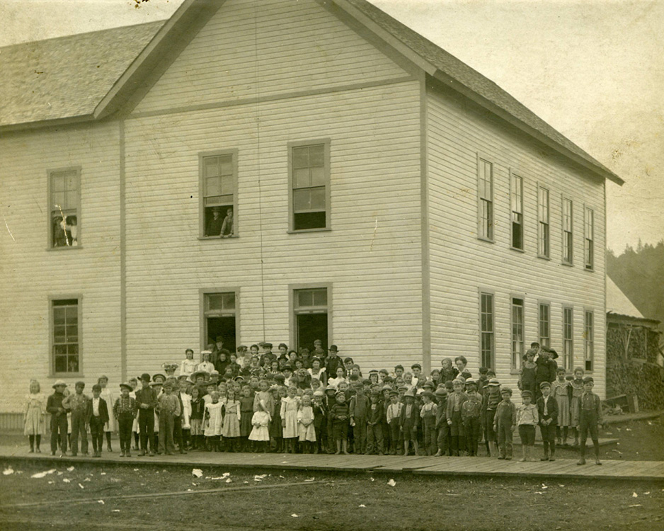
- Pe Ell School
- Pe Ell school children
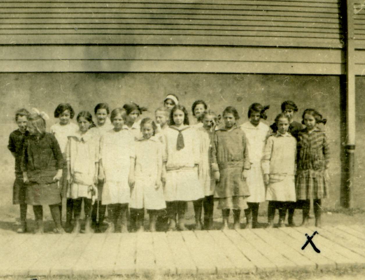
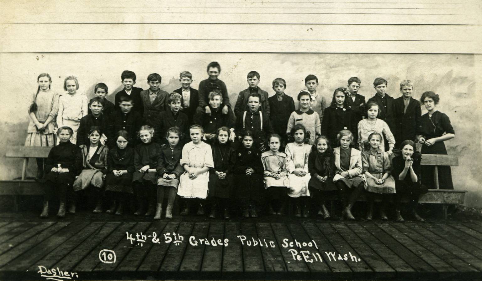
- Pe Ell School, grades 4 and 5
- Pe Ell School, grade 8
- Pe Ell School, grade 2, 1924 - taught by Miss Wiltse.
- Pe Ell School, grade 8, 1930 - taught by Miss Zola Schellenbarger.
- Pe Ell High School, Senior class, 1937
- 50th Reunion of the Class of 1937, Pe Ell High School (in 1987).
- Pe Ell High School
- "Lewis County to Willapa Bay by Rail" - the Summer/Fall 2006 issue of the Sou'wester, a publication by the Pacific County (WA) Historical Society. A great article describing the rail line from Lewis County to Pacific County, with information about, and photos of the towns and depots that lined the route.
- "Lumberjack Legends" - published in "Pacific Northwest Forum", these articles included a series of letters written by Lynn A. Hull, a Pe Ell native, describing life as a logger. [note: not all of the letters published in the journal were posted online] Part 1 (Fall 1976 issue), Part 2 (Winter 1977 issue), Part 4 (Fall 1977 issue), Part 6 (Winter 1978 issue), Part 8 (Fall 1978 issue)
- News from Pe Ell - published in "The Chehalis Bee-Nugget", 4 Dec 1931
Peters
Pomona
See Adna.
Phillips
Pleasant Hill
Located northeast of Curtis and southwest of Adna. Families in Pleasant Hill were enumerated as part of Adna in the 1920 and 1930 censuses.
Pleasant Hill Links:
- Pleasant Hill (Wasson) Cemetery (Curtis) - transcribed for the Washington Tombstone Transcription Project
- News from Pleasant Hill - published in "The Chehalis Bee-Nugget", 30 Oct 1931
- News from Pleasant Hill - published in "The Chehalis Bee-Nugget", 4 Nov 1931
- News from Pleasant Hill - published in "The Chehalis Bee-Nugget", 18 Dec 1931
Prescott
The Prescott precinct appears in all censuses from 1900 - 1930. From the 1930 census, homes were enumerated along Winlock-Toledo Rd and Winlock-Vader Rd., suggesting that Prescott was located near Winlock. The present-day voting precinct of Prescott is bounded by Interstate 5 on the east, Evaline on the northwest, and Winlock on the southwest.
Prescott Links:
Randle
Located 17 miles east of Morton on US Hwy 12. The town was founded in 1886 and named for James Randle, of the Randle Lumber Co. (Tacoma Public Library). Additional information on the namesake of Randle was provided by Whitney McMahan: "My Randles family's name is spelled Randall in that census. You see, James Lawson Randles was also my great great grandfather. Randle was named for him after petitioning Congress for a Post Office. The powers to be dropped the "s" from his name. While James Randles always signed his name with the "s" his children dropped the "s" after his death. He is buried in Centralia and his head stone says James Lawson Randles. I also have a state certified copy of General Election Returns for November 2, 1886. J L Randell (once again spelled wrong) was elected the first Justice of the Peace and he won all 12 votes. Before migrating west from Sevier County Tenn. he held public office as Coroner in London County, Tenn., Register of Deeds in Sevier County, Tenn., four years, and Deputy County Clerk in Sevier County for four years. I also have his original discharge papers from the civil war. While reading the discriptions of Lewis County Towns I found a few errors. Randle is 17 miles east of Morton and my family has no information that there was ever a Randle Lumber Co. We do not believe it to be so. James Lawson Randles was a Farmer and a Merchant and a Politician. He also owned the Randles Hotel in Centralia."
Randle Links:
- Entry for Randle in the "Oregon, Washington and Alaska Gazetteer and Business Directory, 1901-1902"
- 1910 Census Index, Randle Precinct, ED 128-07A to 128-14A and 128-18A to 128-18B
- News from Randle - published in "The Chehalis Bee-Nugget", 20 Nov 1931
- News from Randle, published in "The Lewis County Advocate", 8 Jan 1932
- Notes from Randle, published in "The Chehalis Bee-Nugget", 15 Jan 1932
- News from Randle, published in "The Chehalis Bee-Nugget", 10 Feb 1932
- News from Randle - published in "The Lewis County Advocate", 28 Nov 1940
- News from Randle - published in "The Lewis County Advocate", 12 Dec 1940
- News from Randle - published in "The Lewis County Advocate", 26 Dec 1940
- Randle High School Commencement, June 1937 - newspaper article listing 1937 graduates of Randle High School.
- "Randle High School Reunion" - newspaper article describing a 1962 reunion of the Classes of 1951, 1952 and 1953
- Kehoe Cemetery - transcribed for the Washington Tombstone Transcription Project
- Kiona Cemetery - transcribed for the Washington Tombstone Transcription Project
- Silver Creek Cemetery, contributed by Jenna Cain
- Walter Koher Place Cemetery - transcribed for the Washington Tombstone Transcription Project
- White Pass School District
Rankin
Located 1 mile southwest of Onalaska. Joseph Rankin established a post office here on Oct. 10, 1882 and named it for his family. Other postmasters were James Russell and Theodore B. Flint. The PO was discontinued Dec. 3, 1895 (Ramsey, p. 57).
Rankin Links:
- Entry for Rankin in the "Oregon, Washington and Alaska Gazetteer and Business Directory, 1901-1902"
Reliance
This post office was established south of Alder, below the Pierce-Lewis County border, and operated from August 28, 1913 to September 30, 1914 (Ramsey, p. 138).
Reynolds
Located on Rock Creek near Walville and the Pacific County border (3 miles southwest of Pe Ell). The town was built around a sawmill and named for J. W. Reynolds. When the timber supply was exhausted the town was abandoned; nothing is left of the town site except for a cleared tract of land. A post office operated from Nov. 2, 1900 to May 31, 1904, but served only a few families (Ramsey, p. 117). Ches Packer sent the following message to correct a discrepancy on the Lewis County Map: "On the map shown I found a small discrepancy in the location of the settlement called Reynolds. It was quite small and had a post office for only a few years. On the map it is shown as existing between McCormick and Pe Ell. Its actual location was on the other side (west of) McCormick, between McCormick and Walville. Pe Ell and McCormick were about 2 to 2.5 miles apart. McCormick and Walville were about 1.5 to 2 miles apart so the area involved is quite limited. Reynolds was located on a small fairly level area just to the north of the railroad line which is now a hiking trail and which lies adjacent to Highway 6. I recall a few old collapsing buildings there when I was a boy in the 1930's. The location was just east of the bridge that crosses over Rock Creek and the trail. The settlement was confined pretty well to the area between the railway (now trail) and Rock Creek since there is a steep rock cliff on the south side of the highway and building there would have been too difficult."
Reynolds Links:
- Entry for Reynolds in the "Oregon, Washington and Alaska Gazetteer and Business Directory, 1901-1902"
- See the biography for Carroll L. Brown, whose wife was the daughter of J. W. Reynolds.
- "Lewis County to Willapa Bay by Rail" - the Summer/Fall 2006 issue of the Sou'wester, a publication by the Pacific County (WA) Historical Society. A great article describing the rail line from Lewis County to Pacific County, with information about, and photos of the towns and depots that lined the route.
Rhine
Located 3.5 miles southwest of Randle. A post office operated here from June 24, 1908 to Feb. 28, 1921 (Ramsey, p. 131).
Riffe
Located on the Cowlitz River 8 miles southwest of Morton. The town originally called Baugh but was renamed in honor of Floyd L. Riffe, founder of the Primitive Baptist Church in 1890 and the town's first postmaster in 1897. The post office was closed on May 31, 1966 and Riffe was abandoned when the Mossyrock Dam was built and is now flooded by Riffe Lake (Ramsey, p. 109). In the late 1980s, during a severe summer drought, Riffe Lake grew so shallow that the town was again visible, for the first time since the dam was built.
Riffe Links:
- Entry for Riffe in the "Oregon, Washington and Alaska Gazetteer and Business Directory, 1901-1902"
- Read more about Floyd Riffe and the town of Riffe
- Riffe Cemetery list
- Smith Cemetery list
- Jeff Steiner's website (original no longer available, so this link points to a snapshot on the Internet Archives) - lots of pictures of Kosmos, Riffe Lake and surrounding areas, taken when the lake was at a record low level.
- Primitive Baptist Church - brief histories of the two churches in Riffe, as well as information on how to learn more about members.
- Miscellaneous Town News - published in "The Chehalis Bee-Nugget", 25 Sep 1931
- New from Riffe - published in "The Chehalis Bee-Nugget", 15 Jan 1932
Riley
The post office operated from March 13, 1905 to Aug. 31, 1907 and the only postmaster was the town's namesake, Robert E. Riley (Ramsey, p. 123).
Rock Creek
See Walville.
Roosevelt
Located 4-5 miles northeast of Silver Creek. The town was named in honor of Theodore Rooselvelt when he was campaigning for US Presidency. The post office operated here from Oct. 1, 1900 to Dec. 31, 1901 (Ramsey, p. 114).
Ruth
Located about 1.5 miles northwest of Curtis on Boistfort Road (where it meets SR 6). It was a station on the Milwaukee line, and for a while, was the departure point for lumber milled by sawmills in Klaber, Curtis and surrounding areas. An article in the January 1927 issue of "Milwaukee Magazine" describes the naming of Ruth as follows: "This station was named for Ruth Donahoe, daughter of the Hon. Francis Donahoe, pioneer resident of Lewis County and purchasing agent for the right of way for the railroad west of Chehalis. She drove the family car when taking officials over the proposed route and at the end of an unusually hard trip, C. A. Goodnow, vice-president, complimented her on her driving and named the townsite they had reached for her. She is now Mrs. Ruth Dorr of Portland, Oregon. Francis Donahoe was a leading factor in the development of this section of the country. He was elected state senator and a delegate to several national conventions. While a member of the state legislature he introduced and secured passage of the Donahoe Road Law under which many counties in the state have built miles of roads." (p. 7).
Saint Urban
St. Urban's Catholic Church is located 4.5 miles south of Napavine, Washington on Military Road. The church was built in 1891 and is still an active parish today. St. Urban's cemetary dates back to 1901. It is believed that during the early 1900s the parish had about 50 families. Mass is held once a month on the third Saturday. (Submitted by John Planinshek).
St. Urban Links
- "These Walls Do Talk - Old Churches Tell the History of Lewis county" - article by Nancy Keaton that features several historic church buildings, including St. Urban Catholic Church.
- St. Urban's Catholic Church Cemetery Burial Listing - transcribed for the Washington Tombstone Transcription Project
- News from St. Urban, published in "The Advocate", 22 Jan 1932.
- News from St. Urban, published in "The Advocate", 22 Aug 1940.
Salal
See Dryad.
Salkum
Located 18 miles west of Morton on US Hwy 12. The name comes from the Indian word for boiling, in reference to the "boiling" Mill Creek (Nix, p. 38). It was originally settled by William Hammil and his wife, and was once the site of two sawmills until the timber supply was depleted (Nix, p. 38). The original site of the town was 2 miles south of its present location. The post office was established by Jacob Beusch at the old site on Oct. 10, 1882, and moved to its new location on May 5, 1890 (Ramsey, p. 57).
Salkum Links:
- Entry for Salkum in the "Oregon, Washington and Alaska Gazetteer and Business Directory, 1901-1902"
- 1910 Census Index, Salkum Precinct, ED 143-01A to 143-03B
- News from Salkum - published in "The Chehalis Bee-Nugget", 2 Oct 1931
- News from Salkum - published in "The Daily Chronicle", 26 Sep 1935
- News from Salkum - published in "The Chehalis Advocate", 7 Mar 1940
- News from Salkum - published in "The Advocate", 1 Aug 1940
- News from Salkum - published in "The Advocate", 5 Dec 1940
- Salkum Cemetery - transcribed for the Washington Cemetery Project
- Salkum Church of the Brethren - photo and history of this church (est. 1938)
- View a picture of the Salkum Mill and Dam
Salmon Creek
Salmon Creek (the watercourse) is located southeast of Toledo, near the Lewis-Cowlitz Co. Border (see section F5 of the Lewis Co. Road Atlas), so this precinct was probably a community located near the creek.
Salmon Creek Links:
Salzer
Located directly southeast of Centralia, at the south end of Salzer Creek. Named for Joseph and Anna Marie Salzer. (Tacoma Public Library). (See section E4 of the Lewis Co. Road Atlas.)
Salzer Links:
- 1910 Census Index, Salzer Precinct, ED 124-06A to 124-08B
- 1940 Census Index, Salzer Precinct, ED 21-79
- For more information, see the listing for Salzer Valley in Meany's "Origin of Washington Place Names".
Sharon
Located 5 miles east of Forest. A post office operated here from May 31, 1899 to Sept. 30, 1903 (Ramsey, p. 113).
Sharon Links:
- Entry for Sharon in the "Oregon, Washington and Alaska Gazetteer and Business Directory, 1901-1902"
Shoestring
"Shoestring is about 5 or 6 miles east of Onalaska on Hwy 508. Not a town, (wide place in the road) though when I was a kid, there was a store right there on the hwy. We went to the community church there, which is right across the road from the cemetery. Those who live in Shoestring are in the Onalaska School District. Named after a wild flower (Delphinium)." (From John Blair). See also Alpha.
Shoestring Links:
- News from Shoestring, published in "The Lewis County Advocate", 10 Oct 1935
- Shoestring Valley Cemetery - transcribed for the Washington Tombstone Transcription Project
Siler
Located east of Vance and named for Judson S. Siler. Rufus T. Siler, was postmaster at Vance in 1886 and 1896. Guy Ramsey wrote that Judson and Rufus were brothers, but they were in fact cousins, as clarified by Jenna Cain: "Rufus was the son of David Weimar Siler and Martha Jane Osborne. Judson S. Siler was the son of Thomas Siler, a brother of David Weimar. A quite comprehensive history of the Siler family is in the Chehalis Bee-Nugget August 8, 1930, under the heading of SILER FAMILY HAS A REUNION AT RANDLE SUNDAY. Rufus was married to Josephine Landes, who was a sister of my maternal grandmother."
Silver Brook
The US Geological Survey's Geographic Name Server (GNIS) lists Silver Brook as a "populated place" near Randle. No further information available.
Silver Creek
Located 15 miles west of Morton and one mile north of the Mayfield Dam on Hwy 12. John Tucker founded the town on April 28, 1868. It once had a large dance hall and was the site of popular dances, attended by many of the families in the Tilton and Cowlitz River Valleys (La Gra, p. 10).
Silver Creek Links:
- For more information, see the listing for Silver Creek in Meany's "Origin of Washington Place Names".
- Entry for Silver Creek in the "Oregon, Washington and Alaska Gazetteer and Business Directory, 1901-1902"
- News from Silver Creek, published in "The Lewis County Advocate", 6 Nov 1934.
- News from Silver Creek, published in "The Advocate", 2 Jan 1940.
- News from Silver Creek - published in "The Lewis County Advocate", 28 Nov 1940
- "Silver Creek Rainbow Plans Saturday Afternoon Installation" - published in "The Daily Chronicle", 17 May 1962
- View a map of Silver Creek precinct, from the Lewis County Public Works Dept. Road Atlas.
Skookumchuck
Located between the Lewis Co.-Thurston Co. border and Centralia. Skookumchuck was the site of the first post office in Lewis County, established Oct. 10, 1857 by Charles Van Wormen. The post office was moved to Centerville (later renamed Centralia) in 1877 (Middlesworth, p. 38).
Skookumchuck Links:
- 1870 Census, Skookum Chuck Precinct, pages 0156A-0158B
- 1910 Census Index, Skookumchuck Precinct, ED 139-01A to 139-09A and 139-15A
Sopenah
See Little Falls.
Spencer
In 1924, Spencer was a station on the Cowlitz, Chehalis and Cascade Railway, 3 miles from Chehalis.
Spruce
Located 5 miles southwest of Salkum. In 1898, the population of Spruce numbered about 125. The post office operated from May 17, 1898 to March 5, 1900. The first and only postmaster was Miss Catherine Spencer, who also operated a general store. She married James S. Carpenter on Sept. 5, 1906 (Ramsey, p. 109).
Spruce Links:
- Entry for Spruce in the "Oregon, Washington and Alaska Gazetteer and Business Directory, 1901-1902"
Sticklin
Stillwater
This precinct is listed in the 1910 census, but no further information is available. According to an article in the January 1927 issue of "Milwaukee Magazine", it was named for Stillwater, Minnesota.
Stillwater Links:
Sulphur Creek
This enumeration district was located near Ferry and Mayfield districts.
Sulphur Creek Links:
Sulphur Springs
Established on June 30, 1890. Located near present-day Packwood. A mineral spring of this name was across the Cowlitz River from the mouth of Johnson Creek. For several years, the mail was carried by donation labor. The mail was very light and was carried on a saddlehorn (Ramsey, p. 91).
Sulphur Springs Links:
- Entry for Sulphur Springs in the "Oregon, Washington and Alaska Gazetteer and Business Directory, 1901-1902"
- Rural Scenes, Early Washington - a collection of photographs put together by Mike Huntington, including the Garrison family of Klikitat Prairie and Huntington family of Sulphur Springs. [8/10/14: The original article is no longer available online. This link points to an archived version of it on the Internet Archives.]
Summit
Swofford
Located 10 miles southwest of Morton and named for Thomas R. Swofford in 1887. A post office was established in 1890, and Thomas Swofford served as the first postmaster. The post office was discontinued April 29, 1922 (Ramsey, p. 75). The City of Tacoma bought the town for its Cowlitz River project.
Swofford Links:
- For more information, see the listing for Swofford in Meany's "Origin of Washington Place Names".
- Entry for Swofford in the "Oregon, Washington and Alaska Gazetteer and Business Directory, 1901-1902"
- Swofford Valley Cemetery - transcribed for the Washington Tombstone Transcription Project
- Swofford Valley Cemetery - photos of the cemetery and several gravestones, contributed by LaVonne Schoneman and Tami (DeRossett) Moorcroft.
- Notes from Swofford, published in "The Chehalis Bee-Nugget", 16 Oct 1931
- Notes from Swofford, published in "The Chehalis Bee-Nugget", 15 Jan 1932
Syverson
Named for Harry Syverson, the first manager of Hill Logging Co. For a brief time, it was a station on the South Bend line of the Northern Pacific Railway. See Carl Staeger's article about the South Bend line. Rich Detering adds the following: "I'm old enough to remember the remnants of the old sawmill in Adna on the South Bend line. Littell is only a little more than than a mile to the east and about one third of that stretch, next to Littell, is a swamp. So the Syverson "station" couldn't be more than 1/2 mile from Adna. I would think that talking the railroad company into adding another station between two existing stations separated by a little more than a mile would take some really fast talking! Then getting it named after yourself, what a guy!"
Tasunshun
See Fords Prairie.
Temple
Temple was also known as the Davis Lake settlement. It was settled by Henry Clay Temple and his family in the mid-1880s. They began the Lake Creek Shingle mill in the late 1880s. No post office was ever established, although opportunity to have one was presented in 1890 (La Gra, p. 21).
Temple Links:
- 1900 Census, Morton Precinct - complete transcription of Morton precinct, which included most of the Temple homesteads in the area.
- 1930 Census, Temple Precinct, ED 21-81
Tilden
Located on Bear Canyon Road, 23 miles west of Morton along SR 508 (between Cinebar and Alpha). The post office was established on July 13, 1882 by Mrs. Richard (Sarah) Parnell (La Gra, p. 1).
Tilden Links:
- Entry for Tilden in the "Oregon, Washington and Alaska Gazetteer and Business Directory, 1901-1902"
Tilton
Tilton Links:
- For more information, see the listing for Tilton River in Meany's "Origin of Washington Place Names".
- 1900 Census, Tilton Precinct - complete transcription of the Tilton Precinct
- 1910 Census Index, Tilton Precinct, ED 125-01A to 125-01B
- 1930 Census, Tilton Precinct, ED 21-82
- 1940 Census Index, Tilton Precinct, ED 21-86
Toledo
(1999 population: 690) Located 15 miles south of Chehalis on SR 503. Founded in 1837, its original names were Plomondoe's Landing, Cowlitz Landing, and Warbassport. A post office here operated as Cowlitz from April 29, 1854 to Nov. 30, 1880, when it was renamed Toledo (Ramsey, p. 9). The name Toledo comes from the pioneer side wheel steamer.
Toledo Links:
- For more information, see the listing for Toledo in Meany's "Origin of Washington Place Names".
- Entry for Toledo in the "Oregon, Washington and Alaska Gazetteer and Business Directory, 1901-1902"
- 1910 Census Index, Toledo Precinct, ED 144-01A to 144-05A
- See the biography for Horace Howe, a noted resident of the Toledo area.
- Lone Hill Cemetery, Toledo - transcribed for the Washington Tombstone Transcription Project
- Roberts Cemetery (a.k.a. Howe), Toledo - transcribed for the Washington Tombstone Transcription Project
- St. Francis Xavier Mission Catholic Cemetery - transcribed for the Washington Tombstone Transcription Project
- Toledo Cemetery, A - L - transcribed for the Washington Tombstone Transcription Project
- Toledo Cemetery, M - Z - transcribed for the Washington Tombstone Transcription Project
- St. Francis Xavier Mission
- "These Walls Do Talk - Old Churches Tell the History of Lewis county" - article by Nancy Keaton that features several historic church buildings, including St. Frances Xavier Mission.
- Background and History of the Cowlitz Tribe - written by Rudolph C. Ryser (Cowlitz) for the Center for World Indigenous Studies.
- "The Dispossessed: The Cowlitz Indians in Cowlitz Corridor - written by Judith W. Irwin, and published in Columbia journal, Summer 1994. This PDF is posted on the Center for World Indigenous Studies website.
- The South Lewis County Chamber of Commerce
- Toledo High School, 1914
- Newspaper article about Toledo schools, 1922
- Toledo High School Baseball Team, 1930
- Onalaska and Toledo FFA Teams, 1959, published in "The Chehalis Advocate", 5 Nov 1959
- Toledo Main Street, 1913
- View a Toledo Postcard, ca 1916
- "A Scene Along the Road to Cowlitz Prairie" (postcard, ca 1916)
- News from Toledo - published in "The Chehalis Bee-Nugget", 2 Oct 1931
- "Toledo Honor Roll Announced" - published in "The Chehalis Bee-Nugget", 23 Oct 1931
- News from Toledo - published in "The Chehalis Bee-Nugget", 6 Nov 1931
- News from Toledo - published in "The Chehalis Bee-Nugget", 13 Nov 1931
- News from Toledo - published in "The Chehalis Bee-Nugget", 20 Nov 1931
- More news from Toledo - published in "The Chehalis Bee-Nugget", 20 Nov 1931
- News from Toledo - published in "The Chehalis Bee-Nugget", 4 Dec 1931
- News from Toledo - published in "The Chehalis Bee-Nugget", 8 Jan 1932
Union
This precinct is listed in the 1910 and 1930 censuses. According to the Lewis County Public Works dept., the Union Precinct is located in the Chehalis Valley area, with the Newaukum forming the western boundary, Sturdevant Road forming part of the northern boundary, and Jackson Highway forming part of the southeastern boundary. I have no further information on this locale.
Union Links:
- 1910 Census Index, Union Precinct, ED 141-01A to 141-05A
- Union Precinct Map - links to the Lewis County Public Works deptartment website.
Vader
(1999 population: 490) Located 20 miles southwest of Chehalis on SR 506, on Olequa Creek. The town was originally called Sopenah, but the first post office was established as Little Falls on June 24, 1874, by Paul C. Craft. The town was renamed for a German settler by the name of Vader in April, 1913 (Ramsey, p. 44). To the best of my knowledge, this is the only town in Lewis County in which a name-change was passed into law by the Washington Territorial Legislature.
Vader Links:
- For more information, see the listing for Vader in Meany's "Origin of Washington Place Names" (which includes a first-hand account of the trouble that went into naming Vader).
- Read a biography of Vader doctor, R. H. Campbell
- Vader Servicemen in World War I
- "These Walls Do Talk - Old Churches Tell the History of Lewis county" - article by Nancy Keaton that features several historic church buildings, including Grace United Methodist Church in Vader.
- Vader Catholic Cemetery - transcribed for the Washington Tombstone Transcription Project
- The South Lewis County Chamber of Commerce
- WA Ghost Towns - Little Falls
- News from Vader - published in "The Chehalis Bee-Nugget", 30 Oct 1931
- News from Vader - published in "The Chehalis Bee-Nugget", 11 Dec 1931
- News from Vader - published in "The Chehalis Bee-Nugget", 8 Jan 1932
- "One Way Traffic To Vader" - published in "The Chehalis Bee-Nugget", 8 Jan 1932
- News from Vader - published in "The (Lewis County) Advocate", 18 Apr 1940
- News from Vader - published in "The (Lewis County) Advocate", 28 Nov 1940
Vance
Located 20 miles southeast of Morton (or 1.5 miles south of Randle) on the Cowlitz River. In 1885 it was named for U.S. Senator Zebulon Baird Vance. A post office operated from 1886 to 1927, with Rufus T. Siler as the first postmaster (Ramsey, p. 63) (see also "SILER FAMILY HAS A REUNION AT RANDLE SUNDAY").
Vance Links:
- For more information, see the listing for Vance in Meany's "Origin of Washington Place Names".
- Entry for Vance in the "Oregon, Washington and Alaska Gazetteer and Business Directory, 1901-1902"
Veness
Located 1 mile south of Winlock, near the site of the Menefee station. George W. Veness was the first postmaster, establishing the post office on June 3, 1908. He was a brother of J. A. Veness, who owned a sawmill in Winlock and operated Veness as a company town. The PO was discontinued July 31, 1912 (Ramsey, p. 130).
Veness Links:
- 1910 Census Index, Veness Precinct, ED 127-18A to 127-21A
- Veness Mill Site - contributed by Don Olson
Vern
Established as Verndale on July 26, 1890. The location was 24 miles East of Mossyrock in Rainy Creek Valley. The same horse was used six days a week to make the round trip from Sulphur Springs to Randle and back. It should be noted that there was not yet a place called Randle so it is assumed that volunteers made contact with a carrier near or at the site which later became Randle. Sulphur Springs was renamed Lewis on November 4, 1910. Lewis was renamed Packwood on April 1, 1930 (Ramsey p. 91, p. 134).
Verndale
See Glenoma.
Wabash
Located one mile north of Centralia. The Northern Pacific railway named it in 1908 after the Wabash River, which forms the boundary between Indiana and Illinois.
Walville
Located 4 miles southwest of Pe Ell along SR 6, on the Pacific County border. It was founded in 1898 by two lumbermen from Michigan--Walworth and Neville. It was originally called Rock Creek and was the site of the Rock Creek Lumber Co. The Walville Mill was unique in employing Japanese workers (74 in 1909). The mill closed in 1930 and the town is now abandoned (Erickson, p. 52).
Walville Links:
- 1930 Census, McCormick-Walville Precinct, ED 21-58
- 1940 Census Index, Walville, ED 21-60
- For more information, see the listing for Walville in Meany's "Origin of Washington Place Names".
- Walville Lumber Co. crew, 1923
- "Lewis County to Willapa Bay by Rail" - the Summer/Fall 2006 issue of the Sou'wester, a publication by the Pacific County (WA) Historical Society. A great article describing the rail line from Lewis County to Pacific County, with information about, and photos of the towns and depots that lined the route.
Watkins
This town is not listed in Guy Ramsey's book, but on Cram's 1909 WA map it appears along the current SR 7, between Mineral and Morton.
Webster
Located 3 miles east of Onalaska. A post office operated here from Feb. 10, 1900 to Nov. 15, 1905 (Ramsey, p. 113). See "The History of Onalaska" for more information.
Webster Links:
- Entry for Webster in the "Oregon, Washington and Alaska Gazetteer and Business Directory, 1901-1902"
Wildwood
Located 10 miles south of Curtis on Buchanan Creek. The area was first settled by Thomas Chapman Naylor and his wife, Catherine Alexander Chapman, in 1881. They established the post office on Aug. 24, 1889 and served as postmasters for a number of years. The post office closed on Aug. 15, 1930. The peak population appeared to be 30 residents in 1907 (Ramsey, p. 73).
Wildwood Links:
- For more information, see the listing for Wildwood in Meany's "Origin of Washington Place Names".
- Entry for Wildwood in the "Oregon, Washington and Alaska Gazetteer and Business Directory, 1901-1902"
Wilson
Located 9 miles south of Mayfield. Reuben Koons established the post office here, which operated from July 11, 1891 to Dec. 15, 1924 (Ramsey, p. 96).
Wilson Links:
- Entry for Wilson in the "Oregon, Washington and Alaska Gazetteer and Business Directory, 1901-1902"
- Index to 1910 Census, Wilson Village, Ferry Precinct, ED 149-02A
Windom
Located 10 miles east of Toledo. A post office operated here from June 19, 1891 to June 30, 1909, but the town site is now a single farm (Ramsey, p. 94).
Windom Links:
- Entry for Windom in the "Oregon, Washington and Alaska Gazetteer and Business Directory, 1901-1902"
- 1900 Census, Windom Precinct, ED 135 (complete transcription)
- Index to 1910 Census, Windom Precinct, ED 149
- 1920 Census, Windom Precinct, ED 141 (complete transcription)
- 1930 Census, Windom Precinct, ED 21-88 (complete transcription)
- "Homestead Cemetery" in Windom - cousins Sarah Withrow and Mira McKinna are the only two burials in this cemetery.
Winlock
(1999 population: 1,225) The fifth-largest town in Lewis County is located 19 miles SW of Chehalis on SR 603. It was originally named Grand Prairie when the first post office was established on July 25, 1861 (Ramsey, p. 20). C. C. Pagget re-named it Winlock in 1874, in honor of Senator Winlock W. Miller, a close friend of Isaac I. Stevens, first governor of Washington (Nix, p. 39). Winlock was incorporated in 1883. It is now a small farming community but was once the site of the first big inland railroad sawmill in the Pacific Northwest. The Ainslie Lumber Co. operated a sawmill, store, and hotel 4 miles south of Winlock from 1884 to 1893 (Erickson, p. 83).
Winlock Links:
- For more information, see the listing for Winlock in Meany's "Origin of Washington Place Names".
- Entry for Winlock in the "Oregon, Washington and Alaska Gazetteer and Business Directory, 1901-1902"
- Read the section on Winlock in Robert A. Reid's 1912 book, "Puget Sound and Western Washington."
- History of Winlock - written by C. C. Hall in 1952, and posted on the City of Winlock website.
- Bill Wall's History of Winlock
- 1910 Census Index, Winlock Town, ED 127-01A to 127-12A and 127-22A
- Snow Cemetery - transcribed for the Washington Tombstone Transcription Project
- "Sacred Heart Catholic Church in Winlock to close next year" - article published in The Daily News on 20 Oct 2013.
- Biographies of Winlock residents: J. A. Veness
- Ainslie-Winlock Families - photographs and historical information on several Ainslie-Winlock families, including the Hendersons, Isaacsons, Olsons, Snows and Toys (contributed by Don Olson).
- Flesher Family of Winlock - photos contributed by Alice Harrison.
- The South Lewis County Chamber of Commerce
- Winlock News - published in "The Chehalis Bee-Nugget", 25 Sep 1931
- Winlock News - published in "The Chehalis Bee-Nugget", 30 Oct 1931
- Winlock News - published in "The Chehalis Bee-Nugget", 20 Nov 1931
- Winlock News - published in "The Chehalis Bee-Nugget", 27 Nov 1931
- Winlock News - published in "The Chehalis Bee-Nugget", 4 Dec 1931
- Winlock News - published in "The Chehalis Bee-Nugget", 11 Dec 1931
- City of Winlock
- Winlock School District
Winston
Located 0.5 miles southwest of Mayfield on Winston Creek and named for T. R. Winston, who settled there in 1875. Other early settlers of the region included James Phillips, Charles Bishop, the Yates, the Dillenbaughs, the Garrisons, and the Hendricks (Hunt and Kaylor, p. 450).
Winston Links:
- For more information, see the listing for Winston Creek in Meany's "Origin of Washington Place Names".
- Owery Cemetery (a.k.a. Wilson Pioneer), Winston - transcribed for the Washington Tombstone Transcription Project